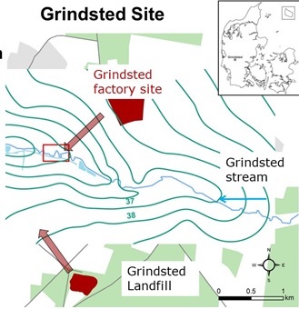
The Grindsted stream site (Jutland) and contaminant sources
The Grindsted stream, located in the Region of Southern Denmark, drains a sandy aquifer and has an average annual discharge of 2000 L/s. The study site comprises a 16 km corridor along Grindsted stream, which has a catchment size of ca. 200 km2, representing a typical Danish landscape with diverse land use activities. Grindsted stream is generally groundwater-fed with a median flow of 2000 L/s and is naturally meandering with only few modifications. The stream depth ranges from 1-2.5 m and the width from 8-12 m.
A plume containing chlorinated ethenes, BTEX (benzene, toluene, ethylbenzene and o,m,p-xylenes) and pharmaceuticals discharge to Grindsted stream from an old factory site located 1.5 km north of the stream. A plume core of approximately 50 m in width and 4 m in thickness, which consist mainly of cis-DCE and vinyl chloride, was delineated along the north bank.
Chlorinated ethenes, BTEX compounds and pharmaceuticals have been observed in the stream water. Vinyl chloride exceeded the Danish environmental quality criteria of 0.05 µg/L more than 7 km downstream of the primary plume discharge zone.
Grindsted Landfill is situated 2 km south of the stream. The landfill leachate plume contaminates the sandy aquifer south of the stream, however, the potential impact on Grindsted stream is not investigated.
Riverscapes activities
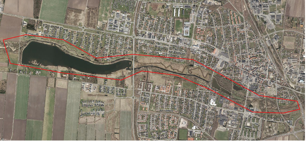
The Riverscapes activities is centered within the area indicated by the red outline on the map below including Grindsted stream, Grindsted Engsø and the boat channel. The overall purpose is to test the new tools developed in Riverscapes under realistic conditions at a field site impacted by a contaminated sites of relevance for Riverscapes partners from Danish Regions. In addition the site is a useful site for application of flow and bathymetry measurements in order to extend the experiences with these technologies.
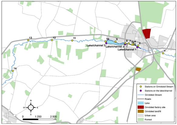
The campaign involves application of a wide range of Riverscapes tools and traditional water flow measurements and water sampling at Grindsted Engsø (lake), along the stream and boat channel:
- Snap shots of hydraulic head at Grindsted Engsø (lake), along the stream and boat channel.
- Mapping of bottom profiles – bathymetry
- Water surface velocity
- Surface water temperature
- Aerial photos and surface elevation at area of certain interest
The water sampling, surface water elevation and flow measurement were extended to cover a wider area in order to establish an overview of the contamination of the stream downgradient of the main entry area and support future modeling activities at the site. The sampling stations are indicated on the map below. This part of the study was supported by additional funding from the Region of Southern Denmark.
Previous studies
The Grindsted area has previous been investigated as part of GEOCON Advancing GEOlogical, geophysical and CONtaminant monitoring technologies for contaminated site investigation http://www.geocon.env.dtu.dk/. The project was supported by InnovationFund Denmark.
Further information
Professor Poul L. Bjerg, Department of Environmental Engineering, email plbj@env.dtu.dk
http://www.grindstedforurening.dk/
Key publications: Grindsted stream
Balbarini, N.; Boon W.; Nicolajsen E..; Nordbotten J.; Bjerg P. L.; Binning P. J. (2017). Model of the influence of meanders on groundwater discharge to streams. Journal of Hydrology. 552, 168–181.
Balbarini, N.; Rønde, V.; Maurya, P.; Fiandaca, G.;Ingelise Møller, I.; Klint, K.E.; Christiansen, A.V.; Philip J. Binning, P.J.; Bjerg, P.L. (2018). Geophysics based contaminant mass discharge quantification downgradient of a landfill and a former pharmaceutical factory. Water Resources Research. 54, 8, 5436-5456.
Cremeans, Mackenzie; Devlin, J.; Osorno, T.; McKnight, U. S.; Bjerg, P. L. (2018). Application of New Point Measurement Device to Quantify Groundwater-Surface Water Interactions. Journal of Contaminant Hydrology. 206, 75-80.
Maurya, P.K.; Balbarini, N.; Balling, I.; Rønde, V.; Christiansen, A.V.; Bjerg, P.L.; Auken, E.; Fiandaca, G. (2018). Subsurface imaging of water electrical conductivity, hydraulic permeability and lithology at contaminated sites by induced polarization. Geophysical Journal International. 213, 2, 770–785.
Rønde, V.; McKnight, U.S.; Sonne, A.Th.; Balbarini, N.; Devlin, J.F.; Bjerg, P.L. (2017). Contaminant mass discharge to streams: comparing direct groundwater velocity measurements and multi-level groundwater sampling with an in-stream approach. Journal of Contaminant Hydrology. 206, 43-54.
Sonne, A.T., McKnight, U.S., Rønde, V., Bjerg, P.L. (2017). Assessing the chemical contamination dynamics in a mixed land-use stream system. Water Research. 125, 141-151.
Sonne; A.T.; Rasmussen, J.J. Höss, S.; Traunspurger, W.; Bjerg, P.L.; McKnight, U.S. (2018). Linking ecological health to co-occurring organic and inorganic chemical stressors in a groundwater-fed stream system. Science of the Total Environment. 642, 1153-1162.