The Usserød stream originates from Sjælsø Lake and stretches ca. 8 km through a peri-urban landscape before merging with the Nivå stream to flow out into the Baltic Sea, as shown in Figure 1 below. Several additional tributaries merge with Usserød stream, where three of the longest are Gedevandsrenden, Blårenden, and the Donse (also shown in the figure).
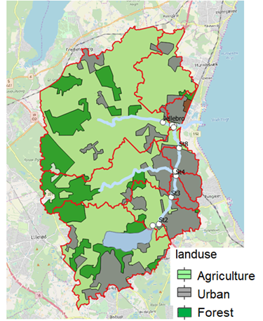
Figure 1: Usserød stream surface water catchment, including different land use types with dark green representing natural areas, light green representing agriculture and gray the urban areas. Water bodies are shown in blue
The surface water catchment comprises ca. 120 km2, with approx. 58% agricultural land-use, 22% urban land use and 17% natural areas, and passes through Rudersdal, Hørsholm and Fredensborg municipalities. There are three dams located along the Usserød stream: Stampedam, Fabriksdam and Mølledam, which were established in the 1800s. Stampedam and Fabriksdam were constructed to supply energy for a military clothing factory, and Mølledam has been historically used by a bakery. In addition, there are three wastewater treatment plants (WWTP) emitting effluents into Usserød stream. Two of them, Sjælsmark and Sjælsø WWTP, discharge approximately 300 meters after the sluice from Sjælsø Lake (just upstream of station 2, see Fig. 1), while Horshølm WWTP is located just after the last dam (and just upstream of station 5). Finally, numerous contaminated sites have been identified within this catchment (see Fig. 2), solidifying its selection as a case study site for the RIVERSCAPES project.
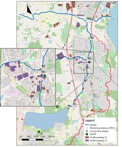
Figure 2: Overview for the location of various contaminated sites identified within the catchment
Over the last two decades, several projects have been carried out with the aim of improving the water quality in the catchment, as well as reducing the risks of urban flooding during heavy rain events. Importantly, this stream system is required to reach good ecological status, as stipulated by the WFD and the associated Danish “Water Plans” (Vandområdplaner 2015-2021: https://mst.dk/natur-vand/vandmiljoe/vandomraadeplaner/vandomraadeplaner-2015-2021/vandomraadeplaner-2015-2021/). While conditions have significantly improved, this goal has yet to be reached.
RIVERSCAPES activities
Eleven stations have been established along this catchment, where nine of them lie along the direct flow path stemming from Sjælsø Lake, and two are located on key tributaries (the Donse and Nivå streams). These were strategically chosen to capture any potential changes in the spectral signals that may be associated with key features in the catchment, such as land use (agricultural vs. urban sampling sites) or tributaries. 9 campaigns to-date have been carried out in conjunction with this field site to determine general water quality variables and flow conditions, spanning a temporal year (from October 2018 to October 2019), and UAV data has been collected 7 times for hyperspectral data, three times for thermal data, and once for WSE. Smaller campaigns have also been conducted for stream discharge (velocimetry). Research into the connections between water quality data and UAV data is still ongoing. A brief overview for key water quality parameters currently under development is given below.
Three key water quality variables, including turbidity, chlorophyll and dissolved organic matter have been chosen for exploring and demonstrating the vast potential UAV data may offer the field of aquatic ecohydrology. Turbidity is a measure of the light-scattering properties of suspended particulates. Remotely-sensed turbidity data can be indirectly linked to water chemistry (nutrients; xenobiotic organic chemicals) that may adversely impact ecosystem health. For example, turbidity as a proxy for suspended solids has been related to particle-bound pollutant concentrations (e.g. polycyclic aromatic hydrocarbons), which may settle to stream sediment where they threaten benthic fauna responsible for numerous ecosystem services (e.g. nutrient cycling). For this reason, in addition to collecting variables related to what UAVs can sense directly, numerous general water quality variables, such as nitrate and phosphate are also collected for exploring the potential to indirectly quantify or link to nutrients present in the water column.
Similarly, dissolved organic matter (DOM) (and chromophoric DOM; the optically active component of DOM) plays an integral role in shaping aquatic systems, where its concentration and composition may directly and indirectly influence (i) biology (microbial/plankton ecology), (ii) chemistry (speciation, transport and toxicity of key contaminants like metals and nutrients) and (iii) optical properties (physics). Recent studies show the large potential for using this parameter to determine contaminant sources and pathways, as well as factors influencing the mobility of key pollutants (e.g. nutrients; metals) in various types of water bodies.
Finally chlorophyll, and its primary photosynthetic pigment chlorophyll-a, is often used as a representative for primary productivity. It is often used for directly monitoring phytoplankton populations (in lakes and coastal systems) and has been directly linked to nutrient pollution. It is therefore one of four key parameters used for risk assessing aquatic ecosystems, together with dissolved oxygen, Escherichia coli and turbidity.
In addition to hyperspectral data, the application of other payloads developed and implemented within the RIVERSCAPES project, are also being explored for use in the context of stream ecology. This includes the thermal payload (for exploring changes in stream temperature, an important stressor and water quality variable), as well as various payloads related to water quantity, including water surface elevation (WSE) and stream discharge (velocimetry techniques), and their implementation with a decision support system context, as indicated above.